Travel Algeria
Algeria Uncovered: Navigating Africa’s Hidden Giant—From Ancient Ruins to Desert Vistas

While Algeria is the largest country in Africa, it remains one of its least visited major destinations, offering a journey through Roman ruins, vast deserts, and vibrant cities, but requiring careful planning due to unique challenges.
Essential Pre-Travel Planning
Visa Process: Mandatory for nearly all travelers and can be lengthy. Independent tourists must apply in advance at an Algerian Embassy, with processing times varying from weeks to over a month.
Key Requirement: You must provide proof of accommodation for every night of your stay. For the Sahara (south of Ain Salah), a pre-booked guided tour is mandatory for the visa.
Best Time to Visit: Spring (April-May) and Autumn (October-November) offer ideal weather across the country. Avoid the scorching Sahara summers and the wet, cold coastal winters.
Critical Safety & Security Advice
Border Areas: Avoid all travel to areas near the borders with Libya, Mali, Mauritania, and Niger due to terrorism and kidnapping risks. The border with Morocco is closed.
General Caution: Exercise a high degree of caution nationwide. Terrorist groups remain active, primarily targeting security forces, but attacks could occur in places frequented by foreigners.
Travel in the South: Only visit Saharan regions by air and always with a reputable tour guide. Independent travel is not permitted in the deep south.

Travel Regions & Key Destinations
Travel experiences and regulations differ significantly between the north and south.
Northern Algeria welcomes independent travelers and is well-served by trains, buses, and shared taxis. In Algiers, explore the UNESCO-listed Casbah, and don’t miss the remarkable Roman ruins at Timgad—often called the “Pompeii of Africa”, as well as Djemila and Tipasa. Constantine, known as the “city of bridges,” offers dramatic cliffside views and striking architecture.
Southern Algeria, encompassing the Sahara, requires guided tours by law and is usually reached via domestic flights. Highlights include the M’zab Valley, a UNESCO World Heritage site featuring distinctive fortified oasis towns like Ghardaïa, and Tassili n’Ajjer, a remote plateau renowned for its prehistoric rock art. The region also offers immersive desert adventures and encounters with Tuareg culture.
Money, Connectivity & Language
Currency: Use cash (Algerian Dinar). Bring Euros or USD to exchange locally, as foreign cards are rarely accepted.
Exchange Note: The unofficial exchange rate is significantly better than the official bank rate, but exchanging on the "black market" is illegal.
Internet & SIM: Public Wi-Fi is scarce. Purchase a local SIM card (Mobilis or Ooredoo are recommended) for mobile data.
Language: Arabic and French are widely spoken; English is not common. A translation app is very useful.
Cultural Etiquette & Local Life
Dress Code: Dress modestly, covering shoulders and knees, especially outside major cities and when visiting religious sites.
Local Interaction: Algerians are known for being exceptionally friendly and hospitable to visitors. Always ask permission before taking photos of people.
Dining: Couscous is the national dish. Alcohol is not widely available except in some hotels in the north.

Algeria is a country in North Africa, constitutionally designated as an Islamic state, with Sunni Islam being the official religion practiced by the vast majority of its population. The name "Algeria" is derived from its capital city, Algiers. The city's name in Arabic is "Al-Jazā'ir," which translates to "the islands," a reference to the four small islands that historically lay off its coast before being connected to the mainland in the 16th century.
To its west, Algeria shares a border with Western Sahara, a territory whose status is internationally disputed. Western Sahara is classified by the United Nations as a non-self-governing territory. It is not internationally recognized as annexed by any single country. Instead, the territory is subject to conflicting claims and is partially controlled by Morocco, while the Polisario Front, a Sahrawi national liberation movement, controls other areas and seeks independence. Algeria, which hosts Sahrawi refugees and supports the Polisario Front's right to self-determination, is a key party in this long-standing regional conflict.
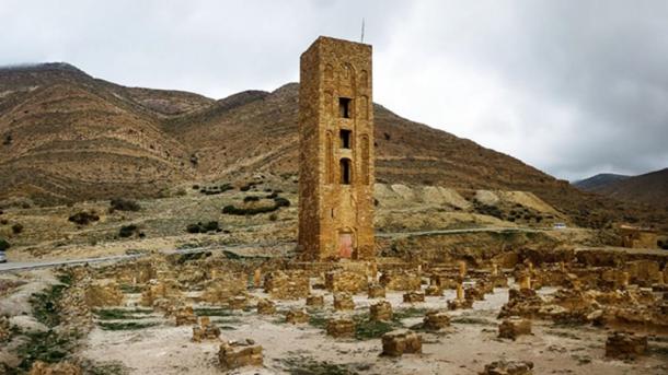
Minaret Near Beni Hammad Fort,Algeria
Exploring the Diverse Landscapes: The Geography of Algeria
The islands off the coast of Algiers are not just a minor geographical footnote; they are central to the identity and name of the city and, by extension, the entire country. The city's Arabic name, Al-Jazāʾir (الجزائر), translates directly to "The Islands". This name originates from four main islands that once lay off the city's western cape, which served as the focal point for its early settlement.
The islands were physically connected to the mainland in 1525 through harbor construction, including a structure known as the Kheireddine pier, permanently anchoring them to the city's landscape. Historically, the name is a shortened form of Jazaʾir Banī Mazghanna ("Islands of the Banu Mazghanna"). Some medieval geographers also offered a more poetic interpretation, viewing the entire fertile Algerian coast, caught between the Mediterranean Sea and the vast Sahara Desert, as a metaphorical "island" of life.
The description of Algeria's coast as "hilly, often times even mountainous" is accurate but only tells part of the story. This northern region, known as the Tell, is a complex and rugged terrain where coastal plains alternate with significant mountain ranges. The coastline itself is dominated by mountain chains that are part of the larger Atlas system, often falling steeply into the sea.

Mountainous Character: The Tell is framed and bisected by parallel mountain ranges. The Tell Atlas runs closest to the coast, while the Saharan Atlas lies further south, with high plateaus in between. This makes the coastal region not merely hilly but distinctly mountainous. For instance, the Kabylie region features massifs like the Djurdjura, where peaks exceed 2,000 meters and are snow-capped in winter.
Narrow Coastal Strip: The fertile coastal plain is often narrow and discontinuous, squeezed between the Mediterranean and the rising mountains. In some areas, such as east of Algiers towards Bejaia, mountains plunge directly into the sea, leaving only a sliver of land.
Historical and Agricultural Heartland: Despite its ruggedness, this coastal strip and its intermountain valleys (like the Mitidja Plain near Algiers) constitute the country's historical, demographic, and agricultural core, hosting most of its population and farmable land.
In essence, the geography of northern Algeria is defined by this dramatic ascent from the Mediterranean, where the historical "islands" of Algiers are just a small part of a much larger, mountainous terrain that has shaped the country's development.

Algeria Travel Guide and Planning Tips
Algeria’s Mediterranean coastline is rugged, creating few natural harbors. Just inland to the south lies the fertile agricultural heartland known as the Tell. Beyond this, the terrain rises into the Atlas Mountains, which then give way to the vast expanse of the Sahara Desert in the far south. Major cities such as Algiers, Oran, and Constantine are primarily located in or near the coastal and Tell regions.

Algeria's Climate: From Mediterranean Coasts to Saharan Extremes
Algeria's climate is defined by significant regional contrasts, largely shaped by its geography which transitions from a narrow Mediterranean coastline to vast Saharan expanses. A detailed breakdown of its three primary climatic zones is as follows:
Mediterranean Coast
This region features the classic Mediterranean climate with mild, rainy winters and hot, sunny, humid summers. The coastal plain experiences average summer temperatures around 26–27°C (79–81°F) in August, the warmest month. A notable weather phenomenon is the sirocco, a hot, dry, and dusty wind that originates in the Sahara Desert. When it blows, especially in spring and autumn, it can cause sudden spikes in temperature, sometimes exceeding 40°C (104°F) along the coast, and carries significant amounts of sand and dust.
Mountainous North
Inland from the coast, the climate becomes transitional and more continental. This region includes mountain ranges like the Tell Atlas, which experience moderately rainy conditions and cold, severe winters where precipitation often falls as snow. Cities on the high plateaus, such as Sétif at 1,000 meters, have wider temperature variations, with average winter lows around 5.5°C (42°F) in January. Summers here are hot but less humid than on the coast.
Saharan Desert
Dominating over four-fifths of the country, the Sahara has an intensely hot and arid climate. Rainfall is extremely scarce, often below 100 mm per year, and the skies are predominantly clear. Summer temperatures are extreme, with highs frequently above 40°C (104°F) and the central-southern lowlands being among the hottest places on Earth, where temperatures can reach 50–51°C (122–124°F). Despite the intense daytime heat, nights, and especially winter nights, can be cool to chilly due to the dry air and rapid heat loss. Sandstorms can also occur throughout this vast desert region.
Serengeti National Park,Tanzania
Tweet
Follow @Charlesfrize


